Rest of
tonight

Fog |
Tuesday

Thunder storm |
Tuesday
night

Thunder storm |
Wednesday

Thunder storm |
Wednesday
night

Thunder storm |
Thursday

Thunder storm |
Thursday
night

Thunder storm |
Friday

Fog a.m. |
Friday
night

Fog late |
Saturday

Cloudy |
|
<.1 in. |
<.1 in. |
.25 in. |
<.25 in. |
.1 in. |
<.1 in. |
|
|
|
| Low: 49° |
High: 76° |
Low: 55° |
High: 79° |
Low: 60° |
High: 79° |
Low: 55° |
High: 70° |
Low: 49° |
High: 66° |
| |
|
|
|
|
|
|
|
|
|
NE
calm
|
S→SW
6-18→11-20
mph
|
SW
6-18
mph
|
SW
7-18→11-20
mph
|
WSW
5
mph
|
SW
9-21→13-23
mph
|
W
5-16
mph
|
NW→N
5
mph
|
NE→ESE
3
mph
|
SE
8-20→12-21
mph
|
|
|
|
|
|
UV: 6
High |
|
|
|
|
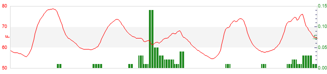
Rest of tonight
|
Partly cloudy. Light to moderate fog. Relatively mild. Low 49°. Wind northeast near calm. |
Tuesday
|
Mostly cloudy to cloudy in the morning, becoming dense overcast in the afternoon. Patchy light fog in the morning. A slight chance of rain. Scattered thunderstorms likely, some possibly severe. Unusually warm. High 76°. Wind south around 6 mph, gusting to 18 mph, in the morning, becoming southwest around 11 mph, gusting to 20 mph, in the afternoon. Chance of precipitation 20 percent. Precipitation mostly less than a tenth of an inch. |
Tuesday night
|
Mostly cloudy. Patchy light fog in the evening, then light to moderate fog after midnight. A slight chance of rain. Scattered thunderstorms likely, some possibly severe. Relatively mild. Low 55°. Wind southwest around 6 mph, gusting to 18 mph. Chance of precipitation 20 percent. Precipitation mostly less than a tenth of an inch. |
Wednesday
|
Cloudy. Patchy light fog in the morning. A slight chance of rain in the morning, then a chance of rain in the afternoon. Thunderstorms very likely, some severe. Exceptionally hot. High 79°. Wind southwest around 7 mph, gusting to 18 mph, in the morning, becoming 11 mph, gusting to 20 mph, in the afternoon. Chance of precipitation 60 percent. Precipitation mostly around a quarter of an inch. |
Wednesday night
|
Dense overcast. Light to moderate fog in the evening, then patchy light fog after midnight. A chance of rain in the evening, then a slight chance of rain after midnight. Scattered thunderstorms likely. Unusually mild. Low 60°. Wind west-southwest around 5 mph. Chance of precipitation 60 percent. Precipitation mostly less than a quarter of an inch. |
Thursday
|
Cloudy in the morning, becoming mostly cloudy in the afternoon. Light to moderate fog in the morning. A slight chance of rain in the morning, then a chance of rain in the afternoon. Thunderstorms very likely, some possibly severe. Exceptionally hot. High 79°. UV index up to 6. Wind southwest around 9 mph, gusting to 21 mph, in the morning, becoming 13 mph, gusting to 23 mph, in the afternoon. Chance of precipitation 50 percent. Precipitation mostly around a tenth of an inch. |
Thursday night
|
Dense overcast. Patchy light fog in the evening, then light to moderate fog after midnight. A chance of rain in the evening, then a slight chance of rain after midnight. Scattered thunderstorms likely, some possibly severe. Relatively mild. Low 55°. Wind west around 5 mph, gusting to 16 mph. Chance of precipitation 40 percent. Precipitation mostly less than a tenth of an inch. |
Friday
|
Cloudy in the morning, becoming mostly cloudy to cloudy in the afternoon. Light to moderate fog in the morning. Unusually warm. High 70°. Wind northwest around 5 mph in the morning, becoming north in the afternoon. |
Friday night
|
Fair to partly cloudy in the evening, becoming mostly cloudy after midnight. Patchy light fog after midnight. Relatively mild. Low 49°. Wind northeast around 3 mph in the evening, becoming east-southeast after midnight. |
Saturday
|
Cloudy. Mild. High 66°. Wind southeast around 8 mph, gusting to 20 mph, in the morning, becoming 12 mph, gusting to 21 mph, in the afternoon. |
WXSIM forecast formatting script by Saratoga-Weather.org.
|